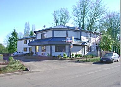
|
OUR
AREA - Local Information
Forest Grove is a city of
approximately 20,500 located 24
miles west of Portland, Oregon. It
is a vibrant metropolitan area with
a population of 2 million.
Surrounded by the rich and
productive farmlands of the Tualatin
Valley, Forest Grove offers urban
amenities in a striking rural
setting.
History:
Home to the Tualatin tribe, the site
of Forest Grove was settled by
pioneers in 1840. Pacific University
was founded in 1849, making it one
of the oldest educational
institutions in the western United
States. The City of Forest Grove was
incorporated in 1872.
The City was named for a large grove
of Oregon white oak situated on a
knoll rising over the Tualatin
Plains. Forest Grove has been
designated a Tree City USA every
year since 1990. Its community
forest is noteworthy for its fine
stands of white oak, its groves of
Douglas fir and stately giant
sequoia. Though not native to
Oregon, giant sequoia seeds were
brought into the area from
California by pioneer John Porter
over a century ago. The Oregon
Department of Forestry has verified
that Forest Grove contains the
largest giant sequoia in Oregon.
Located at the corner of Pacific
Avenue and B Street, this tree is 32
feet in circumference, 152 feet high
and has a crown averaging 70 feet in
diameter.
According to the 2000 Census, Forest
Grove's population is 17,709, an
increase of 31% since 1990. Forest
Grove is now the 26th largest city
in Oregon. More local and regional
Census data is available online.
Forest Grove is located at 45.520
degrees north latitude and 123.109
degrees west longitude.
Geography:
A topographic map (128 K) of Forest
Grove and vicinity.
Forest Grove is situated at the
western margin of the fertile
Tualatin Valley. While the downtown
area is 210 feet above sea level,
hills in the northwestern portion of
the city rise to over 1,100 feet.
The nearby Coast Range attains more
than 3,000 feet and separates Forest
Grove from the coastal city of
Tillamook and its beaches, which are
approximately one hour away. The
vast Tillamook State Forest is less
than a half-hour's drive west of
town.
Mount Hood (11,237 feet), 65 miles
east of Forest Grove, is visible
from many parts of town on clear
days. Other volcanic peaks in the
Cascades, including Mt. St. Helens,
Mt. Adams and Mt. Jefferson, can
also be seen.
The floodplain of the Tualatin River
south of Forest Grove includes the
Fernhill Wetlands, a large wildlife
refuge managed by the Fernhill
Wetlands Management Council. The
wetlands attract thousands of
migratory birds and provide habitat
for many species of mammals and
other birds, including bald eagles.
Gales Creek enters the Tualatin
Valley at Forest Grove from its
source in the Coast Range. Nearby
Hagg Lake provides flood control,
irrigation and recreation for a
large area of Northwest Oregon.
Climate:
Due to its close proximity to the
moderating influence of the Pacific
Ocean, Forest Grove enjoys a mild
climate with few extremes of
temperature. In January, the average
daily maximum temperature is 45.0
degrees, with an average minimum of
32.4 degrees. In July, the average
daily maximum is 82.2 degrees, with
an average minimum of 51.8 degrees.
Annual precipitation in Forest Grove
is 44.58 inches. In an average year,
roughly half that precipitation
falls during the period November
1-January 31st. January is the
snowiest month with about 9 inches
falling in a typical year. Spring
begins early, with the first buds
appearing by the beginning of March.
July and August are usually the
driest months, each averaging less
than 1 inch of rain.
The lowest temperature ever recorded
in Forest Grove was -18 degrees (-28
Celsius) in 1950. The highest
recorded temperature was 109 degrees
(43 Celsius) in 1956.
|